|
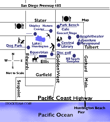
Huntington Beach Central Park Aerial Photo includes most of
the 350+ acres making up Huntington Central Park. Back to
Central Park Main Page
Huntington Beach's Central Park seen in aerial photo above
includes a new Sports Complex with baseball diamonds. The
lake shown in lower left is not accessible to the public.
Lake Huntington is open to the public as a fishing lake seen
in the upper left portion of picture. Next to the playing
fields in the center of the photo is the huge parking lot
for sports activities. Beyond what are actually two sets of
parking lots separated by fencing, there's a perfectly
rectangular-shaped rooftop for the Central Library and
Cultural Center. The lawns and trees behind that
building are home to summer concerts, special events and
walking paths for the public to enjoy daily. On the far
right lower corner of the photo are oil storage drums where
oil is pumped in an underground system and from this
station, transported by trucks.
There's a long ribbon of road that stretches across the
photo horizontally. That is Golden West Street.
On the upper portion of the image is the other half of
Central Park that's separated by that thoroughfare.
Franciscan Fountains housing tract with Mesa View School is
on the upper right. A drainage channel slightly visible as a
gray line in the photo separates it from Shipley Nature
Center which includes that green roof-top structure running
parallel to Golden West Street. Past the brown dirt field in
the upper center portion, is the Huntington Beach Disc Golf
(Frisbee) playing field. Lake Huntington runs along
the perimeter of that course, seen in the upper portion of
the image. On the far left side of the photo in the upper
quadrant are the horse stables and fenced areas of
Huntington Central Park Equestrian Center.
HUNTINGTON
BEACH PARKS & RECREATION
|